The Thorpe Thewles Iron Age Settlement
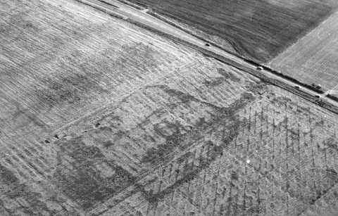
Cropmark of the Thorpe Thewles Iron Age Settlement (Courtesy of Tees Archeology)
In 1977 an archaeological aerial photography survey revealed the cropmark of a large subrectangular enclosure with internal circular features covering just under a hectare. This feature lay at the highest point within the topography of Grindon Parish in a large field east of the A177 and west of the Castle Eden Walkway Centre. Its position would have allowed it unprecedented views over the land around it. The location of the site lay in what by medieval times had become part of Thorpe Thewles' "open field" system and was by then covered with north-south aligned ridge and furrow field strips which lay parallel to the adjacent Stockton to Sedgefield road which is reputably of Roman origin. The field in which the site lay was probably subject to an Elizabethan enclosure award of c. 1600 which broke up the old open fields into allotted portions which were enclosed via the system of hedge rows which in part are still evident today.
Between 1980 and 1982 a series of excavations were carried out on approximately 50% of the site of a cropmark enclosure revealing a complex sequence of occupation stretching from the Mid Iron Age to the 1st century AD with evidence of landscape organization before and after this period. The site proved to be a settlement containing various circular dwelling huts and enclosures within an outer protective bank and ditch system. By the mid second century AD the ditch had become backfilled.
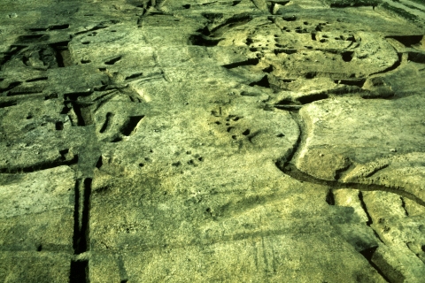
Excavated features of the Thorpe Thewles Iron Age Settlement clearly showing the outlines and post holes of the main circular "round house" (Courtesy of Tees Archeology)
The excavation of the site constituted the most extensive investigation so far undertaken of a later prehistoric settlement site in north-eastern England. The site itself produced the largest collections of Iron Age finds, animal remains and carbonized seeds recovered from northern England to date, and a wide range of structures, enclosures and boundaries were recorded. The results point to an unsuspected level of development in the fertile lowlands of the region.
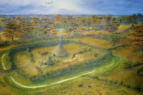
Artists Reconstruction of the Thorpe Thewles Iron Age Settlement c. 200 BC (Courtesy of Tees Archeology)
The ditch forming the enclosure around the earlier habitation phases of the settlement was over 3 m wide and 2 m deep. The spoil dud out to create it had been used to form a bank, probably on its inner side. This bank would have been capped with either a stout wooden fence or a thick hedge to protect the community’s livestock. The entrance to the settlement was located on its southern side.
After the outer ditch the most prominent feature of the site is its large central building, a typical Iron Age "round house" of 12.8 m diameter. This building comprised a wall of upright stakes, coppiced from the surrounding woodlands. These were interwoven with wattle and daub. The house was roofed with a conical framework of rafters, resting on a ring of posts. Thatch would have covered the roof, the eaves of which would have overlapped the walls and almost reached the floor. A substantial drainage ditch surrounded its outer wall. The archeology of this building is extremely complex having three phases of construction and showing evidence of it having been rebuilt at least twice. The life span of the various habitation phases of the house extends over a 70 to a 100 year period. In the final phase of the house's existence the area on which it stood became completely covered by a thick spread of burnt material that spilled across the walls and into the partly filled ditch. The obvious deduction is that the building was destroyed by fire, either deliberately or as the result of a domestic accident.
Initially this house would have been grouped with one or two ancillary buildings but most of the interior of the enclosure would probably have been given over to the coralling of livestock. The erection of numerous structures and the increased use of the space around them meant that the latter phase of activity on the site its protective bank was pushed back into the outer surrounding ditch allowing the site to take on an open character. The ditch became completely filled in with occupation debris, eventually levelling off the site. The settlement by this stage no longer resembled a defended farmstead but would be much closer to a village in size, density and complexity.
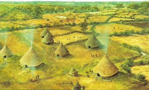
Artists Reconstruction of the Thorpe Thewles Iron Age Settlement c. 50 AD (Courtesy of Tees Archeology)
For further and in depth information about the above site the reader should refer to "The Excavation of an Iron Age Settlement at Thorpe Thewles, Cleveland, 1980-1982" by D.H.Heslop (CBA Research Report 65). To view this report in full go to the appropriate entry in the Links section of this web site.
![]()